ndt_scan_matcher#
Purpose#
ndt_scan_matcher is a package for position estimation using the NDT scan matching method.
There are two main functions in this package:
- estimate position by scan matching
- estimate initial position via the ROS service using the Monte Carlo method
One optional function is regularization. Please see the regularization chapter in the back for details. It is disabled by default.
Inputs / Outputs#
Input#
| Name | Type | Description |
|---|---|---|
ekf_pose_with_covariance |
geometry_msgs::msg::PoseWithCovarianceStamped |
initial pose |
points_raw |
sensor_msgs::msg::PointCloud2 |
sensor pointcloud |
sensing/gnss/pose_with_covariance |
sensor_msgs::msg::PoseWithCovarianceStamped |
base position for regularization term |
sensing/gnss/pose_with_covarianceis required only when regularization is enabled.
Output#
| Name | Type | Description |
|---|---|---|
ndt_pose |
geometry_msgs::msg::PoseStamped |
estimated pose |
ndt_pose_with_covariance |
geometry_msgs::msg::PoseWithCovarianceStamped |
estimated pose with covariance |
/diagnostics |
diagnostic_msgs::msg::DiagnosticArray |
diagnostics |
points_aligned |
sensor_msgs::msg::PointCloud2 |
[debug topic] pointcloud aligned by scan matching |
points_aligned_no_ground |
sensor_msgs::msg::PointCloud2 |
[debug topic] no ground pointcloud aligned by scan matching |
initial_pose_with_covariance |
geometry_msgs::msg::PoseWithCovarianceStamped |
[debug topic] initial pose used in scan matching |
multi_ndt_pose |
geometry_msgs::msg::PoseArray |
[debug topic] estimated poses from multiple initial poses in real-time covariance estimation |
multi_initial_pose |
geometry_msgs::msg::PoseArray |
[debug topic] initial poses for real-time covariance estimation |
exe_time_ms |
tier4_debug_msgs::msg::Float32Stamped |
[debug topic] execution time for scan matching [ms] |
transform_probability |
tier4_debug_msgs::msg::Float32Stamped |
[debug topic] score of scan matching |
no_ground_transform_probability |
tier4_debug_msgs::msg::Float32Stamped |
[debug topic] score of scan matching based on no ground LiDAR scan |
iteration_num |
tier4_debug_msgs::msg::Int32Stamped |
[debug topic] number of scan matching iterations |
initial_to_result_relative_pose |
geometry_msgs::msg::PoseStamped |
[debug topic] relative pose between the initial point and the convergence point |
initial_to_result_distance |
tier4_debug_msgs::msg::Float32Stamped |
[debug topic] distance difference between the initial point and the convergence point [m] |
initial_to_result_distance_old |
tier4_debug_msgs::msg::Float32Stamped |
[debug topic] distance difference between the older of the two initial points used in linear interpolation and the convergence point [m] |
initial_to_result_distance_new |
tier4_debug_msgs::msg::Float32Stamped |
[debug topic] distance difference between the newer of the two initial points used in linear interpolation and the convergence point [m] |
ndt_marker |
visualization_msgs::msg::MarkerArray |
[debug topic] markers for debugging |
monte_carlo_initial_pose_marker |
visualization_msgs::msg::MarkerArray |
[debug topic] particles used in initial position estimation |
Service#
| Name | Type | Description |
|---|---|---|
ndt_align_srv |
autoware_localization_srvs::srv::PoseWithCovarianceStamped |
service to estimate initial pose |
Parameters#
Core Parameters#
Frame#
| Name | Type | Description | Default | Range |
|---|---|---|---|---|
| base_frame | string | Vehicle reference frame. | base_link | N/A |
| ndt_base_frame | string | NDT reference frame. | ndt_base_link | N/A |
| map_frame | string | Map frame. | map | N/A |
Sensor Points#
| Name | Type | Description | Default | Range |
|---|---|---|---|---|
| required_distance | float | Required distance of input sensor points [m]. If the max distance of input sensor points is lower than this value, the scan matching will not be performed. | 10 | N/A |
Ndt#
| Name | Type | Description | Default | Range |
|---|---|---|---|---|
| trans_epsilon | float | The maximum difference between two consecutive transformations in order to consider convergence. | 0.01 | ≥0.0 |
| step_size | float | The newton line search maximum step length. | 0.1 | ≥0.0 |
| resolution | float | The ND voxel grid resolution. | 2 | ≥0.0 |
| max_iterations | float | The number of iterations required to calculate alignment. | 30 | ≥1 |
| num_threads | float | Number of threads used for parallel computing. | 4 | ≥1 |
Initial Pose Estimation#
| Name | Type | Description | Default | Range |
|---|---|---|---|---|
| particles_num | float | The number of particles to estimate initial pose. | 200 | ≥1 |
| n_startup_trials | float | The number of initial random trials in the TPE (Tree-Structured Parzen Estimator). This value should be equal to or less than 'initial_estimate_particles_num' and more than 0. If it is equal to 'initial_estimate_particles_num', the search will be the same as a full random search. | 20 | ≥1 |
Validation#
| Name | Type | Description | Default | Range |
|---|---|---|---|---|
| lidar_topic_timeout_sec | float | Tolerance of timestamp difference between current time and sensor pointcloud. [sec] | 1 | ≥0.0 |
| initial_pose_timeout_sec | float | Tolerance of timestamp difference between initial_pose and sensor pointcloud. [sec] | 1 | ≥0.0 |
| initial_pose_distance_tolerance_m | float | Tolerance of distance difference between two initial poses used for linear interpolation. [m] | 10 | ≥0.0 |
| critical_upper_bound_exe_time_ms | float | The execution time which means probably NDT cannot matches scans properly. [ms] | 100 | ≥0.0 |
Score Estimation#
| Name | Type | Description | Default | Range |
|---|---|---|---|---|
| converged_param_type | float | Converged param type. 0=TRANSFORM_PROBABILITY, 1=NEAREST_VOXEL_TRANSFORMATION_LIKELIHOOD | 1 | ≥0 ≤1 |
| converged_param_transform_probability | float | If converged_param_type is 0, threshold for deciding whether to trust the estimation result. | 3 | ≥0.0 |
| converged_param_nearest_voxel_transformation_likelihood | float | If converged_param_type is 1, threshold for deciding whether to trust the estimation result. | 2.3 | ≥0.0 |
Covariance#
| Name | Type | Description | Default | Range |
|---|---|---|---|---|
| output_pose_covariance | array | The covariance of output pose. Note that this covariance matrix is empirically derived. | [0.0225, 0.0, 0.0, 0.0, 0.0, 0.0, 0.0, 0.0225, 0.0, 0.0, 0.0, 0.0, 0.0, 0.0, 0.0225, 0.0, 0.0, 0.0, 0.0, 0.0, 0.0, 0.000625, 0.0, 0.0, 0.0, 0.0, 0.0, 0.0, 0.000625, 0.0, 0.0, 0.0, 0.0, 0.0, 0.0, 0.000625] | N/A |
Regularization#
Abstract#
This is a function that adds the regularization term to the NDT optimization problem as follows.
, where t_base is base position measured by GNSS or other means. NDT(R,t) stands for the pure NDT cost function. The regularization term shifts the optimal solution to the base position in the longitudinal direction of the vehicle. Only errors along the longitudinal direction with respect to the base position are considered; errors along Z-axis and lateral-axis error are not considered.
Although the regularization term has rotation as a parameter, the gradient and hessian associated with it is not computed to stabilize the optimization. Specifically, the gradients are computed as follows.
Regularization is disabled by default. If you wish to use it, please edit the following parameters to enable it.
Where is regularization available#
This feature is effective on feature-less roads where GNSS is available, such as
- bridges
- highways
- farm roads
By remapping the base position topic to something other than GNSS, as described below, it can be valid outside of these.
Using other base position#
Other than GNSS, you can give other global position topics obtained from magnetic markers, visual markers or etc. if they are available in your environment.
(Currently Autoware does not provide a node that gives such pose.)
To use your topic for regularization, you need to remap the input_regularization_pose_topic with your topic in ndt_scan_matcher.launch.xml.
By default, it is remapped with /sensing/gnss/pose_with_covariance.
Limitations#
Since this function determines the base position by linear interpolation from the recently subscribed poses, topics that are published at a low frequency relative to the driving speed cannot be used. Inappropriate linear interpolation may result in bad optimization results.
When using GNSS for base location, the regularization can have negative effects in tunnels, indoors, and near skyscrapers. This is because if the base position is far off from the true value, NDT scan matching may converge to inappropriate optimal position.
Parameters#
| Name | Type | Description | Default | Range |
|---|---|---|---|---|
| enable | boolean | Regularization switch. | 0 | N/A |
| scale_factor | float | Regularization scale factor. | 0.01 | ≥0.0 |
Regularization is disabled by default because GNSS is not always accurate enough to serve the appropriate base position in any scenes.
If the scale_factor is too large, the NDT will be drawn to the base position and scan matching may fail. Conversely, if it is too small, the regularization benefit will be lost.
Note that setting scale_factor to 0 is equivalent to disabling regularization.
Example#
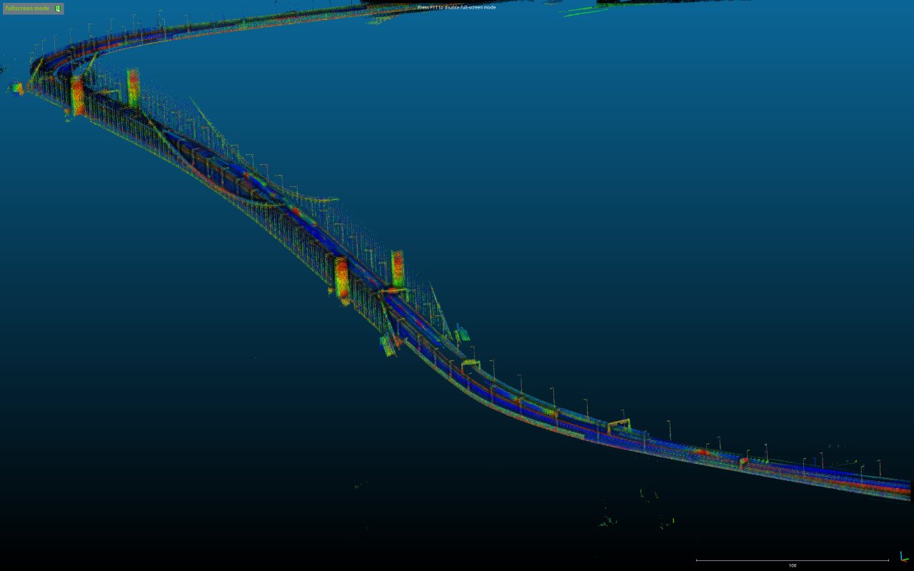
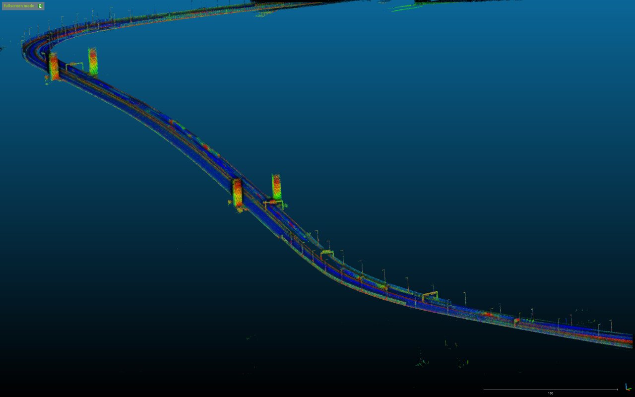
The following figures show tested maps.
- The left is a map with enough features that NDT can successfully localize.
- The right is a map with so few features that the NDT cannot localize well.
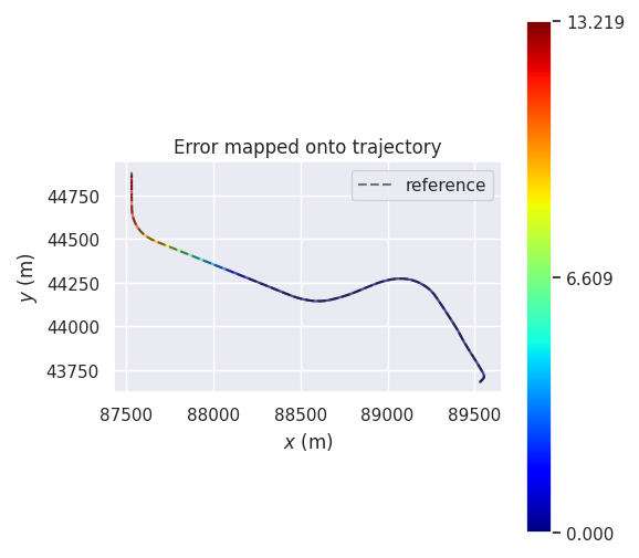
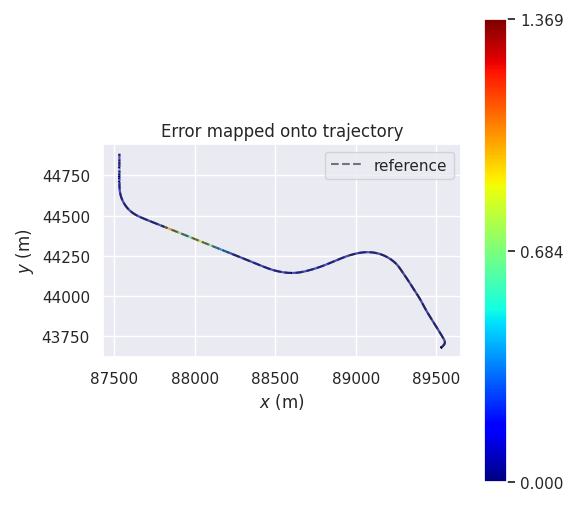
The following figures show the trajectories estimated on the feature-less map with standard NDT and regularization-enabled NDT, respectively. The color of the trajectory indicates the error (meter) from the reference trajectory, which is computed with the feature-rich map.
- The left figure shows that the pure NDT causes a longitudinal error in the bridge and is not able to recover.
- The right figure shows that the regularization suppresses the longitudinal error.
Dynamic map loading#
Autoware supports dynamic map loading feature for ndt_scan_matcher. Using this feature, NDT dynamically requests for the surrounding pointcloud map to pointcloud_map_loader, and then receive and preprocess the map in an online fashion.
Using the feature, ndt_scan_matcher can theoretically handle any large size maps in terms of memory usage. (Note that it is still possible that there exists a limitation due to other factors, e.g. floating-point error)
Additional interfaces#
Additional outputs#
| Name | Type | Description |
|---|---|---|
debug/loaded_pointcloud_map |
sensor_msgs::msg::PointCloud2 |
pointcloud maps used for localization (for debug) |
Additional client#
| Name | Type | Description |
|---|---|---|
client_map_loader |
autoware_map_msgs::srv::GetDifferentialPointCloudMap |
map loading client |
Parameters#
| Name | Type | Description | Default | Range |
|---|---|---|---|---|
| update_distance | float | Dynamic map loading distance. | 20 | ≥0.0 |
| map_radius | float | Dynamic map loading loading radius. | 150 | ≥0.0 |
| lidar_radius | float | Radius of input LiDAR range (used for diagnostics of dynamic map loading). | 100 | ≥0.0 |
Notes for dynamic map loading#
To use dynamic map loading feature for ndt_scan_matcher, you also need to split the PCD files into grids (recommended size: 20[m] x 20[m])
Note that the dynamic map loading may FAIL if the map is split into two or more large size map (e.g. 1000[m] x 1000[m]). Please provide either of
- one PCD map file
- multiple PCD map files divided into small size (~20[m])
Here is a split PCD map for sample-map-rosbag from Autoware tutorial: sample-map-rosbag_split.zip
| PCD files | How NDT loads map(s) |
|---|---|
| single file | at once (standard) |
| multiple files | dynamically |
Scan matching score based on no ground LiDAR scan#
Abstract#
This is a function that uses no ground LiDAR scan to estimate the scan matching score. This score can reflect the current localization performance more accurately. related issue.
Parameters#
| Name | Type | Description | Default | Range |
|---|---|---|---|---|
| enable | boolean | A flag for using scan matching score based on de-grounded LiDAR scan. | 0 | N/A |
| z_margin_for_ground_removal | float | If lidar_point.z - base_link.z <= this threshold , the point will be removed. | 0.8 | ≥0.0 |
2D real-time covariance estimation#
Abstract#
Calculate 2D covariance (xx, xy, yx, yy) in real time using the NDT convergence from multiple initial poses. The arrangement of multiple initial poses is efficiently limited by the Hessian matrix of the NDT score function. In this implementation, the number of initial positions is fixed to simplify the code. The covariance can be seen as error ellipse from ndt_pose_with_covariance setting on rviz2. original paper.
Note that this function may spoil healthy system behavior if it consumes much calculation resources.
Parameters#
initial_pose_offset_model is rotated around (x,y) = (0,0) in the direction of the first principal component of the Hessian matrix. initial_pose_offset_model_x & initial_pose_offset_model_y must have the same number of elements.
| Name | Type | Description | Default | Range |
|---|---|---|---|---|
| enable | boolean | 2D Real-time covariance estimation with multiple searches (output_pose_covariance is the minimum value). | False | N/A |
| initial_pose_offset_model_x | array | Offset arrangement in covariance estimation [m]. initial_pose_offset_model_x & initial_pose_offset_model_y must have the same number of elements. | [0.0, 0.0, 0.5, -0.5, 1.0, -1.0] | N/A |
| initial_pose_offset_model_y | array | Offset arrangement in covariance estimation [m]. initial_pose_offset_model_x & initial_pose_offset_model_y must have the same number of elements. | [0.5, -0.5, 0.0, 0.0, 0.0, 0.0] | N/A |
Diagnostics#
scan_matching_status#
| Name | Description | Transition condition to Warning | Transition condition to Error | Whether to reject the estimation result (affects skipping_publish_num) |
|---|---|---|---|---|
topic_time_stamp |
the time stamp of input topic | none | none | no |
sensor_points_size |
the size of sensor points | the size is 0 | none | yes |
sensor_points_delay_time_sec |
the delay time of sensor points | the time is longer than validation.lidar_topic_timeout_sec |
none | yes |
is_succeed_transform_sensor_points |
whether transform sensor points is succeed or not | none | failed | yes |
sensor_points_max_distance |
the max distance of sensor points | the max distance is shorter than sensor_points.required_distance |
none | yes |
is_activated |
whether the node is in the "activate" state or not | not "activate" state | none | yes |
is_succeed_interpolate_initial_pose |
whether the interpolate of initial pose is succeed or not | failed. (1) the size of initial_pose_buffer_ is smaller than 2. (2) the timestamp difference between initial_pose and sensor pointcloud is longer than validation.initial_pose_timeout_sec. (3) distance difference between two initial poses used for linear interpolation is longer than validation.initial_pose_distance_tolerance_m |
none | yes |
is_set_map_points |
whether the map points is set or not | not set | none | yes |
iteration_num |
the number of times calculate alignment | the number of times is larger than ndt.max_iterations |
none | yes |
local_optimal_solution_oscillation_num |
the number of times the solution is judged to be oscillating | the number of times is larger than 10 | none | yes |
transform_probability |
the score of how well the map aligns with the sensor points | the score is smaller thanscore_estimation.converged_param_transform_probability (only in the case of score_estimation.converged_param_type is 0=TRANSFORM_PROBABILITY) |
none | yes |
nearest_voxel_transformation_likelihood |
the score of how well the map aligns with the sensor points | the score is smaller than score_estimation.converged_param_nearest_voxel_transformation_likelihood (only in the case of score_estimation.converged_param_type is 1=NEAREST_VOXEL_TRANSFORMATION_LIKELIHOOD) |
none | yes |
distance_initial_to_result |
the distance between the position before convergence processing and the position after | the distance is longer than 3 | none | no |
execution_time |
the time for convergence processing | the time is longer than validation.critical_upper_bound_exe_time_ms |
none | no |
skipping_publish_num |
the number of times rejected estimation results consecutively | none | the number of times is 5 or more | - |
※The sensor_points_callback shares the same callback group as the trigger_node_service and ndt_align_service. Consequently, if the initial pose estimation takes too long, this diagnostic may become stale.
initial_pose_subscriber_status#
| Name | Description | Transition condition to Warning | Transition condition to Error |
|---|---|---|---|
topic_time_stamp |
the time stamp of input topic | none | none |
is_activated |
whether the node is in the "activate" state or not | not "activate" state | none |
is_expected_frame_id |
whether the input frame_id is the same as frame.map_frame or not |
none | not the same |
regularization_pose_subscriber_status#
| Name | Description | Transition condition to Warning | Transition condition to Error |
|---|---|---|---|
topic_time_stamp |
the time stamp of input topic | none | none |
trigger_node_service_status#
| Name | Description | Transition condition to Warning | Transition condition to Error |
|---|---|---|---|
service_call_time_stamp |
the time stamp of service calling | none | none |
is_activated |
whether the node is in the "activate" state or not | none | none |
is_succeed_service |
whether the process of service is succeed or not | none | none |
※ This diagnostic is only published when the service is called, so it becomes stale after the initial pose estimation is completed.
ndt_align_service_status#
| Name | Description | Transition condition to Warning | Transition condition to Error |
|---|---|---|---|
service_call_time_stamp |
the time stamp of service calling | none | none |
is_succeed_transform_initial_pose |
whether transform initial pose is succeed or not | none | failed |
is_need_rebuild |
whether it need to rebuild the map. If the map has not been loaded yet or if distance_last_update_position_to_current_position encounters is an Error state, it is considered necessary to reconstruct the map, and is_need_rebuild becomes True. |
none | none |
maps_size_before |
the number of maps before update map | none | none |
is_succeed_call_pcd_loader |
whether call pcd_loader service is succeed or not | failed | none |
maps_to_add_size |
the number of maps to be added | none | none |
maps_to_remove_size |
the number of maps to be removed | none | none |
map_update_execution_time |
the time for map updating | none | none |
maps_size_after |
the number of maps after update map | none | none |
is_updated_map |
whether map is updated. If the map update couldn't be performed or there was no need to update the map, it becomes False |
none | is_updated_map is False but is_need_rebuild is True |
is_set_map_points |
whether the map points is set or not | not set | none |
is_set_sensor_points |
whether the sensor points is set or not | not set | none |
best_particle_score |
the best score of particle | none | none |
is_succeed_service |
whether the process of service is succeed or not | failed | none |
※ This diagnostic is only published when the service is called, so it becomes stale after the initial pose estimation is completed.
map_update_status#
| Name | Description | Transition condition to Warning | Transition condition to Error |
|---|---|---|---|
timer_callback_time_stamp |
the time stamp of timer_callback calling | none | none |
is_activated |
whether the node is in the "activate" state or not | not "activate" state | none |
is_set_last_update_position |
whether the last_update_position is set or not |
not set | none |
distance_last_update_position_to_current_position |
the distance of last_update_position to current position |
none | (the distance + dynamic_map_loading.lidar_radius) is larger than dynamic_map_loading.map_radius |
is_need_rebuild |
whether it need to rebuild the map. If the map has not been loaded yet or if distance_last_update_position_to_current_position encounters is an Error state, it is considered necessary to reconstruct the map, and is_need_rebuild becomes True. |
none | none |
maps_size_before |
the number of maps before update map | none | none |
is_succeed_call_pcd_loader |
whether call pcd_loader service is succeed or not | failed | none |
maps_to_add_size |
the number of maps to be added | none | none |
maps_to_remove_size |
the number of maps to be removed | none | none |
map_update_execution_time |
the time for map updating | none | none |
maps_size_after |
the number of maps after update map | none | none |
is_updated_map |
whether map is updated. If the map update couldn't be performed or there was no need to update the map, it becomes False |
none | is_updated_map is False but is_need_rebuild is True |