The traffic_light_occlusion_predictor Package#
Overview#
traffic_light_occlusion_predictor receives the detected traffic lights rois and calculates the occlusion ratios of each roi with point cloud.
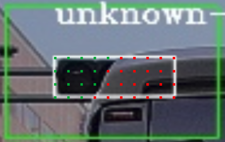
For each traffic light roi, hundreds of pixels would be selected and projected into the 3D space. Then from the camera point of view, the number of projected pixels that are occluded by the point cloud is counted and used for calculating the occlusion ratio for the roi. As shown in follow image, the red pixels are occluded and the occlusion ratio is the number of red pixels divided by the total pixel numbers.
If no point cloud is received or all point clouds have very large stamp difference with the camera image, the occlusion ratio of each roi would be set as 0.
Input topics#
| Name | Type | Description |
|---|---|---|
~input/vector_map |
autoware_auto_mapping_msgs::HADMapBin | vector map |
~/input/rois |
autoware_auto_perception_msgs::TrafficLightRoiArray | traffic light detections |
~input/camera_info |
sensor_msgs::CameraInfo | target camera parameter |
~/input/cloud |
sensor_msgs::PointCloud2 | LiDAR point cloud |
Output topics#
| Name | Type | Description |
|---|---|---|
~/output/occlusion |
autoware_auto_perception_msgs::TrafficLightOcclusionArray | occlusion ratios of each roi |
Node parameters#
| Parameter | Type | Description |
|---|---|---|
azimuth_occlusion_resolution_deg |
double | azimuth resolution of LiDAR point cloud (degree) |
elevation_occlusion_resolution_deg |
double | elevation resolution of LiDAR point cloud (degree) |
max_valid_pt_dist |
double | The points within this distance would be used for calculation |
max_image_cloud_delay |
double | The maximum delay between LiDAR point cloud and camera image |
max_wait_t |
double | The maximum time waiting for the LiDAR point cloud |